Monday, March 29, 2010

Olavinlinna Castle in Finland

Olavinlinna (Swedish: Olofsborg; literally St. Olaf's Castle, see Olaf II of Norway) is a 15th century three-tower castle located inSavonlinna, Finland. It is northernmost medieval stone fortress still standing.

Construction
The fortress was founded by Erik Axelsson Tott in 1475 under the name Sankt Olofsborg in an effort to profit from the political turmoil following Ivan III's conquest of the Novgorod Republic. It was sited in Savonia so as to lay claim to the Russian side of the border established by the Treaty of Nöteborg.
One of Tott's letters from 1477 includes a passing mention of foreign builders invited to Olofsborg, probably from Reval, where the city fortifications were being extended. It was the first Swedish castle provided with a set of thickset circular towers that could withstandcannon fire. It is not by accident that a network of lakes and waterways forms the setting for the castle, for these would seriously impede a prospective Russian offensive.

History
Olofsborg withstood several sieges by the Russians during the the First and Second Russian-Swedish wars. A brisk trade developed under the umbrella of the castle towards the end of the 16th century, giving birth to the town of Savonlinna, which was chartered in 1639.
On 28 July 1714 the garrison capitulated to the invading Russians, and it took them only two days to take the castle in 1743, in the events leading up to the Treaty of Abo which awarded the entire region to Empress Elizabeth of Russia.

Tourism

Currently, the castle hosts several small exhibitions, including the Castle Museum which displays artifacts found in the castle or related to it, and the Orthodox Museum which displays icons and other religious artifacts both from Finland and Russia. The castle forms a spectacular stage for the Savonlinna Opera Festival, held annually in the summer since 1912.

Olavinlinna is the initial model for Kropow Castle in the comic book King Ottokar's Sceptre, an album in the series of Adventures of Tintin created by Hergé.


References

http://en.wikipedia.org/wiki/Olavinlinna

Sunday, March 28, 2010

World of Photos...

Sunday, January 31, 2010

Mount Field National Park...

Mount Field National Park is a national park in Tasmania (Australia), an hour (64 km) northwest of Hobart. The landscape ranges from eucalyptus temperate rainforest to alpine moorland, rising to 1,434 metres (4,705 ft) at the summit of Mount Field West.
History
Mount Field National Park was founded in 1916, making it, along with Freycinet National Park, Tasmania's oldest national park. The area around Russell Falls has been protected for its natural beauty since 1885, when it was set aside as Tasmania's first nature reserve. The last known wild thylacine was captured in the region in 1933. The reserve was called "National Park" before 1946, but was officially renamed to its present name in 1947.
Geology
During the Pleistocene period a snowfield covered the top of the Mt Field plateau which fed glaciers in the surrounding valleys. A large, 12 km long glacier formed the broad river valley and the cirque walls above lake seal. Twisted Tarn, Twilight Tarn and the tarns on the tarn shelf were formed by glacial scouring. A glacier flowed south from the Rodway Range, forming lakes Belcher and Nelton, and north to form the Hayes Valley and Lake Hayes.
In alpine areas podzolic, humus and leached soil is most common. The podzols often occur on deep periglacial solifunction depsoits down to 450m. Alluvial floodplains have developed in the lower park on deposits of quaternary alluvium.
Fauna
The park has good representation of much of native Tasmania fauna including Wombat, Platypus, eastern barred bandicoot and the Tasmanian devil.
Accommodation & Facilities.

There is camping, with powered and unpowered sites at the entrance to the Park, as well as the Government-owned Lake Dobson cabins near the end of the access road within the Park. Several private ski/walking clubs have private huts, and a ski-lodge on the ski slopes has limited accommodation during the skiing season.

Beside the Visitor Centre there are picnic and barbecue facilities, as well as a playground and public toilets.

Activitie

From the visitor centre:

Mt Field is a popular national park in Tasmania.

  • Russell Falls is an easy, 20 minute return walk on asphalt and boardwalks.
  • Horseshoe Falls is a 30 minute walk.
  • The Lady Barron Falls circuit (via Russell Falls and Horseshoe Falls) is approximately 2 hours return.
  • Tall Trees Walk is an easy thirty minute walk through the tall swamp gums.

Walks from the Lake Dobson car park include:

  • The Ski Lodge and Lake Seal lookout, 1 hour return.
  • Seager's Lookout, 2 hours return.
  • Mt Field East va Lake Nicholls, 5 hours return.
  • Mt Field West, 8 hours return.
  • Tarn Shelf, Lake Newdegate, Twilight Tarn and Lake Webster circuit, 6 hours return.

Mt Field National park has one of Tasmania's downhill skiing areas. There are three ski tows, two on Mt Mawson and one on the Rodway range. There is generally sufficient snow cover for skiing from mid July to mid September.

References

Tasmania Parks and Wildlife Service website

http://en.wikipedia.org/wiki/Mount_Field_National_Park

Lady Barron Falls...

Lady Barron Falls is a cascading waterfall located within a few kilometres of Russell Falls in the Mount Field National Park. The waterfall is named after Lady Clara Barron, wife of Sir Harry Barron.

Wednesday, December 30, 2009

Krak des Chevaliers, Crusader fortress, Syria.

Krak des Chevaliers (French pronunciation: [kʁak de ʃəvaˈlje]), transliterated Crac des Chevaliers, is a Crusader fortress in Syriaand one of the most important preserved medieval military castles in the world. In Arabic, the fortress is called Qal'at al-Ḥiṣn(Arabic: قلعة الحصن‎), the word Krak coming from the Syriac karak, meaning fortress. It is located approximately 40 km west of the city of Homs, close to the border of Lebanon, and is administratively part of the Homs Governorate.
Known to the Arabs as Hisn al Akrad (Arabic: حصن الأکراد‎), the Castle of the Kurds, it was called by the Franks Le Crat and then by a confusion with karak (fortress), Le Crac.
The castle is located east of Tripoli, Lebanon, in the Homs Gap, atop a 650-metre-high hill along the only route from Antioch toBeirut and the Mediterranean Sea. It is one of many fortresses that were part of a defensive network along the border of the oldCrusader states. The fortress controlled the road to the Mediterranean, and from this base, the Hospitallers could exert some influence over Lake Homs to the east to control the fishing industry and watch for Muslim armies gathering in Syria.

The original fortress at the location had been built in 1031 for the emir of Aleppo.

During the First Crusade in 1099 it was captured by Raymond IV of Toulouse, but then abandoned when the Crusaders continued their march towards Jerusalem. It was reoccupied again by Tancred, Prince of Galilee in 1110. In 1142 it was given by Raymond II, count of Tripoli, to the Hospitallers, contemporaries of the Knights Templar.

Krak des Chevaliers was the headquarters of the Knights Hospitaller during the Crusades. It was expanded between 1150 and 1250 and eventually housed a garrison of 2,000. The inner curtain wall is up to 100 feet thick at the base on the south side, with seven guard towers 30 feet in diameter.

The Hospitallers rebuilt it and expanded it into the largest Crusader fortress in the Holy Land, adding an outer wall three meters thick with seven guard towers eight to ten meters thick to create a concentric castle. The fortress may have held about 50-60 Hospitallers and up to 2,000 other foot soldiers; the Grand Master of the Hospitallers lived in one of the towers. In the 12th century the fortress had a moat which was covered by a drawbridge leading to postern gates.

Between the inner and outer gates a courtyard led to the inner buildings, which were rebuilt by the Hospitallers in a Gothic style. These buildings included a meeting hall, a chapel, a 120-meter-long storage facility, and two vaulted stone stables which could have held up to a thousand horses. Other storage facilities were dug into the cliff below the fortress; it is estimated that the Hospitallers could have withstood a siege for five years.

In 1163 the fortress was unsuccessfully besieged by Nur ad-Din, after which the Hospitallers became an essentially independent force on the Tripolitanian frontier. By 1170 the Hospitallers' modifications were complete. In the late 12th and early 13th century numerous earthquakes caused some damage and required further rebuilding.

Saladin unsuccessfully besieged the castle in 1188. During the siege the castellan was captured and taken by Saladin's men to the castle gates where he was told to order the gates opened. He reportedly told his men in Arabic, the language of his captors, to surrender the castle, but then told them in French to hold the castle to the last man.

In 1217, during the Fifth Crusade, king Andrew II of Hungary strengthened the outer walls and financed the guarding troops.

In 1271 the fortress was captured by Mameluke Sultan Baibars on April 8 with the aid of heavy trebuchets and mangonels, at least one of which was later used to attack Acre in 1291. Baibars refortified the castle and used it as a base against Tripoli. He also converted the Hospitaller chapel to a mosque.

King Edward I of England, while on the Ninth Crusade in 1272, saw the fortress and used it as an example for his own castles in England and Wales.

The fortress was described as “perhaps the best preserved and most wholly admirable castle in the world” by T. E. Lawrence. This fortress was made a World Heritage Site, along with Qal’at Salah El-Din, in 2006, and is owned by the Syrian government. The fortress is one of the few sites where Crusader art (in the form of frescoes) has been preserved.

Tuesday, December 29, 2009

Windsor Castle, Berkshire, United Kingdom.

Windsor Castle, in Windsor in the English county of Berkshire, is the largest inhabited castle in the world and, dating back to the time of William the Conqueror, is the oldest in continuous occupation. The castle's floor area is approximately 484,000 square feet (44,965 square metres).

Together with Buckingham Palace in London and Holyrood Palace in Edinburgh, it is one of the principal official residences of the British monarch. Queen Elizabeth II spends many weekends of the year at the castle, using it for both state and private entertaining. Her other two residences, Sandringham House and Balmoral Castle, are the Royal Family's private homes.

Most of the Kings and Queens of England, later Kings and Queens of Great Britain, and later still kings and queens of the United Kingdom and the other Commonwealth realms, have had a direct influence on the construction and evolution of the castle, which has been their garrison fortress, home, official palace, and sometimes their prison. Chronologically the history of the castle can be traced through the reigns of the monarchs who have occupied it. When the country has been at peace, the castle has been expanded by the additions of large and grand apartments; when the country has been at war, the castle has been more heavily fortified. This pattern has continued to the present day.

Aerial view of the castle.

The Upper Ward from the south west


Windsor Castle's Upper Ward from the north west —The Quadrangle—not open to tourists.

Queens Beast by Ben Harms.


During the latter half of the 20th century Windsor Castle became one of Britain's major tourist attractions.

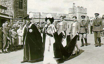
King George VI and Queen Elizabeth, the Queen Mother lead the processions of Knights of the Garter from the castle's Upper Ward to St George's Chapel.

Queen Victoria's retreat into the privacy of the castle after the death of Prince Albert acquired her thesoubriquet "The Widow of Windsor".

St George's Hall in 1848 by Joseph Nash, showing the alterations made for George IV by Sir Jeffry Wyatville.

St George's Hall at Windsor Castle from W.H. Pyne's Royal Residences (1819). This shows thebaroque style of the work carried out at Windsor for Charles II by architect Hugh May, painter Antonio Verrio, carver Grinling Gibbons and others. St George's Hall was redecorated in the early 19th century, but several smaller interiors from this period survive.

The lower ward in the 1840s. St George's Chapel is on the left and the Round Tower is centre right.

Windsor Castle in 1907.

The Round Tower of Windsor Castle.

Plan of Windsor Castle. Throughout this article the letters marked in red are used to refer to locations discussed.

Plan of Windsor Castle in 1743 by Batty Langley.

Windsor Castle, a thousand-year-old fortress transformed into a royal palace. This well-known silhouette of a seeminglymedieval castle was not created, however, until the 1820s by Jeffry Wyatville.

http://en.wikipedia.org/wiki/Windsor_Castle